 Rewind
Historical maps · 28 BC – AD 395
Historical map of Roman Empire
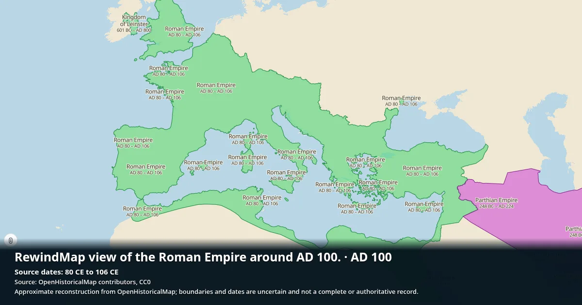
Roman Empire appears on the map from 28 BC to AD 395 (422 years). OpenHistoricalMap records 19 recorded territorial snapshots in dataset.
Open Roman Empire on the interactive map →
Recorded territorial snapshots
| From | To | |
|---|---|---|
| 28 BC | 20 BC | View |
| 20 BC | 17 BC | View |
| 17 BC | 16 BC | View |
| 16 BC | 15 BC | View |
| 15 BC | AD 6 | View |
| AD 6 | AD 42 | View |
| AD 42 | AD 47 | View |
| AD 47 | AD 56 | View |
| AD 56 | AD 80 | View |
| AD 80 | AD 106 | View |
| AD 106 | AD 114 | View |
| AD 114 | AD 116 | View |
| AD 116 | AD 117 | View |
| AD 117 | AD 118 | View |
| AD 118 | AD 198 | View |
| AD 198 | AD 214 | View |
| AD 214 | AD 270 | View |
| AD 270 | AD 383 | View |
| AD 383 | AD 395 | View |
Battles on its territory
Battles whose location falls inside Roman Empire's borders in the year they were fought.
- Battle of Lake Constance · 15 BC· map
- Battle of Londinium · AD 60· map
- Battle of Beth Horon · AD 66· map
- Battle of Jerusalem · AD 66· map
- Siege of Ascalon · AD 67· map
- Battle of Mount Tabor · AD 67· map
- First Battle of Bedriacum · AD 69· map
- Battles of Bedriacum · AD 69· map
- Second Battle of Bedriacum · AD 69· map
- Battle of Adamclisi · AD 101· map
- Battle of Gatae · AD 103· map
- Battle of Sarmisegetusa · AD 106· map
- Battle of Cyzicus · AD 193· map
- Battle of Nicaea · AD 193· map
- Battle of Issus · AD 194· map
- Battle of Lugdunum · AD 197· map
- Battle of Antioch · AD 218· map
- Battle of Resaena · AD 243· map
- Battle of Verona · AD 249· map
- Battle of Philippopolis · AD 250· map
- Battle of Abritus · AD 251· map
- Battle of Barbalissos · AD 252· map
- Battle of Thermopylae (254) · AD 254· map
- Battle of Mediolanum · AD 259· map
- Battle of Edessa · AD 260· map
- Battle of Lake Benacus · AD 268· map
- Battle of Pons Aureoli · AD 268· map
- Battle of Naissus · AD 268· map
- Battle of Fano · AD 271· map
- Battle of Pavia · AD 271· map
- Battle of Placentia · AD 271· map
- Battle of Immae · AD 272· map
- Battle of Emesa · AD 272· map
- Battle of Châlons · AD 274· map
- Battle of Vindonissa · AD 298· map
- Battle of Lingones · AD 298· map
- Battle of Brescia · AD 311· map
- Battle of Verona · AD 312· map
- Battle of Turin · AD 312· map
- Battle of the Milvian Bridge · AD 312· map
- Battle of Tzirallum · AD 313· map
- Battle of Cibalae · AD 314· map
- Battle of Mardia · AD 315· map
- Battle of the Hellespont · AD 324· map
- Battle of Adrianople (324) · AD 324· map
- Battle of Chrysopolis · AD 324· map
- Battle of Mursa Major · AD 351· map
- Battle of Mons Seleucus · AD 353· map
- Battle of Brumath · AD 355· map
- Battle of Durocortorum · AD 355· map
- Battle of Strasbourg · AD 357· map
- Battle of Thyatira · AD 366· map
- Battle of the Willows · AD 376· map
- Battle of Marcianople · AD 376· map
- Battle of Constantinople · AD 378· map
- Battle of Argentovaria · AD 378· map
- Battle of Adrianople · AD 378· map
- Battle of Thessalonica · AD 380· map
- Battle of Lutetia · AD 382· map
- Battle of the Save · AD 387· map
- Battle of the Frigidus · AD 394· map
Same region and period
- Kingdom of Leinster · 601 BC – AD 1603
- Kingdom of Meath · AD 100 – AD 1172
- Roman Italy · AD 7 – AD 292
- Parthian Empire · 248 BC – AD 224
- Dacia Malvensis · AD 167 – AD 275
- Kingdom of Pontus · 282 BC – AD 62
- Dacia Superior · AD 118 – AD 167
What the earliest outline represents
The Roman Empire records shown here begin at 28 BC. This dataset's coverage is not the founding date of Rome. The Metropolitan Museum of Art dates Augustus's rule to 27 BCE–AD 14; use the map to compare those years while keeping its recorded coverage limits in mind.
Sources
Borders: OpenHistoricalMap contributors (CC0 1.0).Wikidata: Q2277.Battles: Wikidata contributors (CC0 1.0).